(207) 762-2010 kimberly.sebold@maine.edu
  • Facebook
  • Facebook
Aroostook County History
  • Home
  • Cemetery Maps
  • StoryMaps
  • Resources
  • Towns of Aroostook
    • Caribou, Maine
    • Easton, Maine
    • Fort Fairfield, Maine
    • Limestone, Maine
    • Mapleton, Maine
    • Mars Hill, Maine
    • Maysville, Maine
    • Presque Isle, Maine
      • Yesterday & Today
    • Washburn, Maine
    • Woodland, Maine
  • Events
  • News
  • About
  • Contact
Select Page

Corner of State & Academy Streets

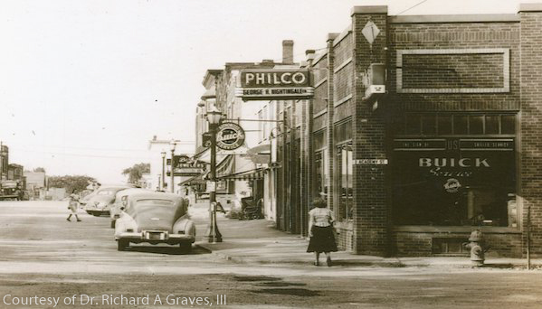
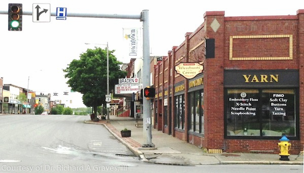
Presque Isle Yesterday & Today

Circa 1950- 2012

Black-and-white photograph of downtown Presque Isle, Maine, showing a mid-20th-century commercial street with brick storefronts, including visible signage for Philco and Buick, vintage automobiles parked along the curb, pedestrians on the sidewalk, and streetlamps lining the road.Color photograph of downtown Presque Isle, Maine, showing a row of brick storefronts along a quiet street, including a shop with large “YARN” signage, traffic lights at an intersection, sidewalk planters, and minimal vehicle traffic.

Caribou Chapman church Easton folklore Fort Fairfield Green Ridge Grendell Irish Main Street Mapleton Mars Hill Mi'kmaq Micmac Mount Shiloh pine Pine Tree Presque Isle Riverside Saint Mary St. Denis St. Mary State Street women's history World War I

  • About
  • News
  • Contact
  • Terms of Use
Designed by the Wicked Good Life | ©Mouse Island Creatives