Maysville, Maine
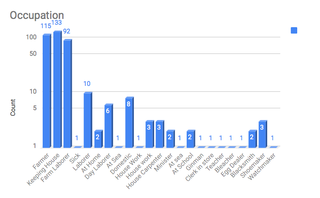
According to George Varney’s, Gazetteer of the State of Maine, published in 1881, Maysville is exclusively an agricultural town lying on the Aroostook River, in Aroostook County, having Fort Fairfield between it and New Brunswick. Caribou bounds it on the north, Presque Isle on the south, and Mapleton and Washburn on the west. The surface of the town is somewhat rolling, but without high elevations, May Hill being the highest. The Aroostook comes in at the west and leaves on the northern border making a complete oxbow about the center of the town. At its exit it receives Hardwood Creek, which comes in at the west along the northern line and at the southwest Presque Isle River joins it from southward. In the western part of the town, the Aroostook flows around many islands. Maysville has one or small sawmills and a starch factory. The factory is of 727 tons capacity, and consumes 140,000 bushels of potatoes in a single season.
The underlying rock in this town is limestone, found everywhere outcropping or under the surface, but seldom more than 20 feet below. The soil, as might be supposed, is quite calcareous. Potatoes are the leading money crop. Hay, wheat and oats are also largely raised and oats are also largely raised, and, like the first, yield well. The forests contain a great variety of trees.
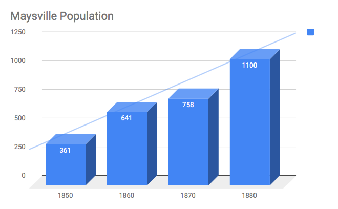
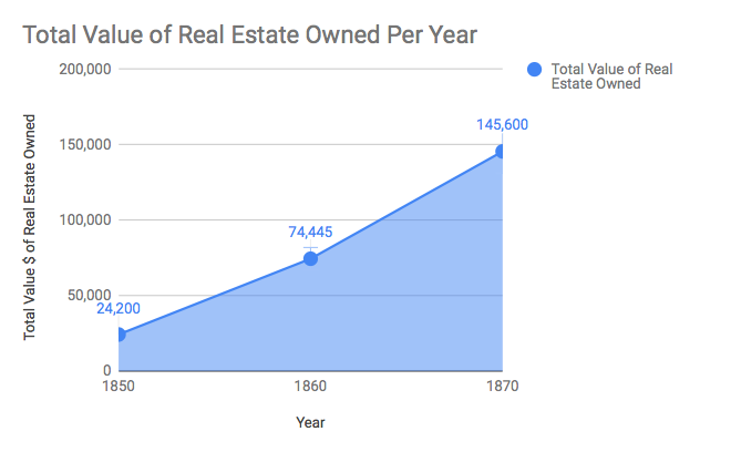
The town is 42 miles N.N.W. of Houlton, on the stage route to Caribou. The latter is 7 miles distant, and furnishes the nearest railroad station. Presque Isle Village, lying near the south line of Maysville, is the center of business for the latter town. Maysville was incorporated, April 4, 1859. The town hall is a large, two-story wooden building nearly new with a school room below. In the spring of 1880, nearly 500 trees, mostly of rock maples, were set out along the highways by members of the Maysville Grange. The people take pride in the excellent roads of the town. A bridge across the Aroostook here is 420 feet in length. The town has 12 schoolhouses, all in good condition. The value of school property is $3,500. The valuation of estates in 1870 was $140,057. In 1880, it was $224,228. The rate of taxation in the latter year was 16 mills on the dollar. The population in 1870 was 758. In 1880, it was 1,141.
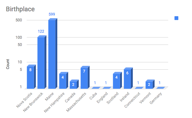
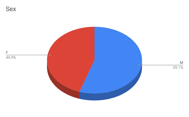
1850 Maysville Census
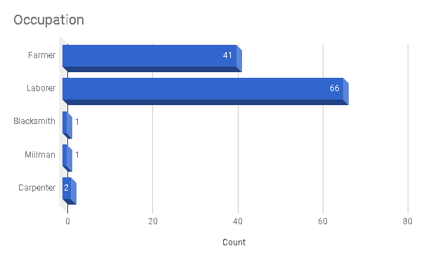
1860 Maysville Census
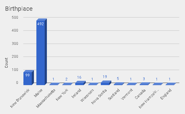
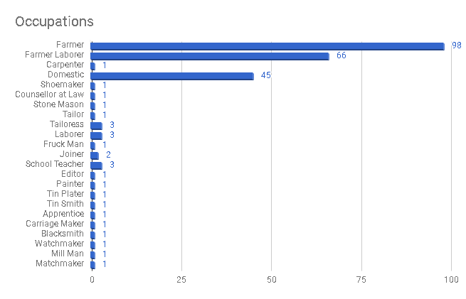
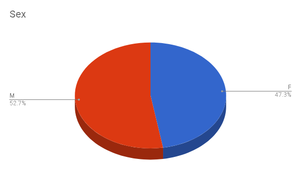
1870 Maysville Census
This is a research study by Evan Zarkadas, a history student at the University of Maine at Presque Isle, on the independent history of the town of Maysville.
The Forgotten History of Maysville*
View a poster project by Evan Zarkadas on the process of Geo-referencing the old township map of Maysville on top of today’s map using GIS technology.
*No part of this document may be used or printed without the permission from Dr. Kimberly Sebold at the University of Maine at Presque Isle. You may ask for permission at kimberly.sebold@maine.edu or if you have any questions for the researcher you can reach out at evanzarkadas@gmail.com.