(207) 762-2010 kimberly.sebold@maine.edu
  • Facebook
  • Facebook
Aroostook County History
  • Home
  • Cemetery Maps
  • StoryMaps
  • Resources
  • Towns of Aroostook
    • Caribou, Maine
    • Easton, Maine
    • Fort Fairfield, Maine
    • Limestone, Maine
    • Mapleton, Maine
    • Mars Hill, Maine
    • Maysville, Maine
    • Presque Isle, Maine
      • Yesterday & Today
    • Washburn, Maine
    • Woodland, Maine
  • Events
  • News
  • About
  • Contact
Select Page

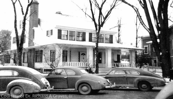
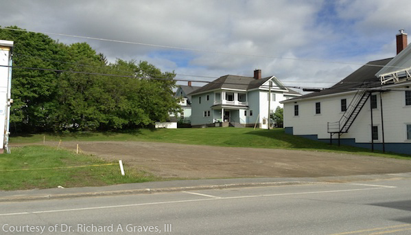
Second Street, Presque Isle, ME

Presque Isle Yesterday & Today

Circa 1947. The home was built in 1918 and then demolished in 1993

Black-and-white photograph of a large two-story house in Presque Isle, Maine, with a wraparound porch and white clapboard siding, partially framed by leafless trees, and several mid-20th-century cars parked along the street in front.Color photograph of a cleared open lot in Presque Isle, Maine, with a paved road in the foreground, grassy ground, utility lines overhead, and two white residential-style buildings at the rear under a partly cloudy sky.

Caribou Chapman church Easton folklore Fort Fairfield Green Ridge Grendell Irish Main Street Mapleton Mars Hill Mi'kmaq Micmac Mount Shiloh pine Pine Tree Presque Isle Riverside Saint Mary St. Denis St. Mary State Street women's history World War I

  • About
  • News
  • Contact
  • Terms of Use
Designed by the Wicked Good Life | ©Mouse Island Creatives