(207) 762-2010 kimberly.sebold@maine.edu
  • Facebook
  • Facebook
Aroostook County History
  • Home
  • Cemetery Maps
  • StoryMaps
  • Resources
  • Towns of Aroostook
    • Caribou, Maine
    • Easton, Maine
    • Fort Fairfield, Maine
    • Limestone, Maine
    • Mapleton, Maine
    • Mars Hill, Maine
    • Maysville, Maine
    • Presque Isle, Maine
      • Yesterday & Today
    • Washburn, Maine
    • Woodland, Maine
  • Events
  • News
  • About
  • Contact
Select Page

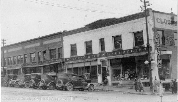
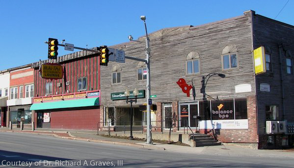
Main and State Streets Intersection

Presque Isle Yesterday & Today

The so-called Green’s Corner in 1925. The building was constructed in 1914.

Black-and-white historical photograph of a Presque Isle, Maine commercial block featuring Greene’s Clothing and neighboring storefronts, with early automobiles parked diagonally along the street, pedestrians on the sidewalk, and period signage visible on brick and wood-frame buildings.Color photograph of a downtown streetscape in Presque Isle, Maine, showing a row of older commercial buildings with mixed brick and weathered wood facades, storefront windows, signage for local businesses, and traffic lights at an intersection along a wide street.

Caribou Chapman church Easton folklore Fort Fairfield Green Ridge Grendell Irish Main Street Mapleton Mars Hill Mi'kmaq Micmac Mount Shiloh pine Pine Tree Presque Isle Riverside Saint Mary St. Denis St. Mary State Street women's history World War I

  • About
  • News
  • Contact
  • Terms of Use
Designed by the Wicked Good Life | ©Mouse Island Creatives